Fișier:Earth dry elevation.stl
Aspect
mută în bara laterală
ascunde
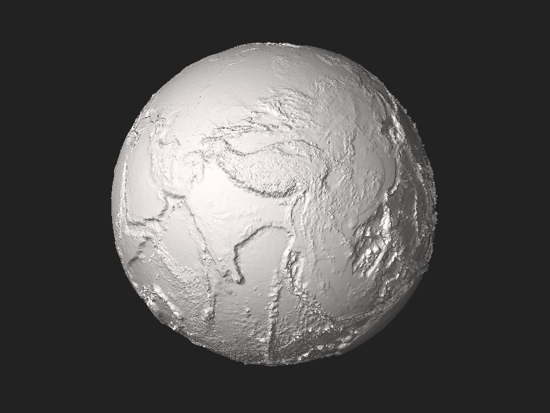
Mărimea acestei previzualizări PNG a acestui fișier STL: . Alte rezoluții: | | | | | .
Mărește rezoluția imaginii (5.120 × 2.880 pixeli, mărime fișier: 27,66 MB, tip MIME: application/sla)

View Earth dry elevation.stl on viewstl.com
Descriere fișier
| DescriereEarth dry elevation.stl |
English: Earth without liquid water greatly exaggerated elevation model by CMG Lee using depthmap File:Earth_dry_elevation.png generated from NASA Visible Earth topography and bathymetry data. |
| Dată |
15 aprilie 2018 |
| Sursă |
Operă proprie |
| Autor |
Cmglee |
| Alte versiuni |
|
Python source
#!/usr/bin/env python
exaggeration = 10
header = ('Dry Earth %s-times-exaggerated elevation model by CMG Lee using NASA data.'
% (exaggeration))
path_png_alt = 'earth_dry_elevation.png' ## 1-channel equirectangular PNG
luma_datum = 141 ## image intensity level (of 0-255) of datum
radius_datum = 6378.137 ## mean radius of zero level in km
f_wgs84 = 1 / 298.257223563 ## WGS84 flattening factor
km_per_luma = (10.994 + 8.848) / 255 * exaggeration ## min and max elevations in km
scale = 1e-2 ## overall scale of model in km^-1
lat_offset = 5.0 / 8 ## rotation around planet axis in revolutions
n_division = 200 ## each cubic face divided into n_division^2 squares
class Png:
def __init__(self, path):
(self.width, self.height, self.pixels, self.metadatas) = png.Reader(path).read_flat()
def __str__(self): return str((self.width, self.height, len(self.pixels), self.metadatas))
import time, re, math, struct, png
time.start = time.time()
def log(string): print('%6.3fs\t%s' % (time.time() - time.start, string))
def fmt(string): ## string.format(**vars()) using tags {expression!format} by CMG Lee
def f(tag): i_sep = tag.rfind('!'); return (re.sub('\.0+$', '', str(eval(tag)))
if (i_sep < 0) else ('{:%s}' % tag).format(eval(tag)))
return (re.sub(r'(?<!{){+}', lambda m:f(m.group()), string)
.replace('{{', '{').replace('}}', '}'))
def append(obj, string): return obj.append(fmt(string))
def tabbify(cellss, separator='|'):
cellpadss = * (len(max(cellss, key=len)) - len(rows)) for rows in cellss]
fmts = )) for cols in zip(*cellpadss)]
return '\n'.join()
def hex_rgb(colour): ## convert RGB to #RRGGBB and RRGGBB to #RRGGBB
return '#%s' % (colour if len(colour) > 4 else ''.join()).lstrip('#')
def viscam_colour(colour):
colour_hex = hex_rgb(colour)
colour_top5bits = , 16) >> 3 for i in range(1,7,2)]
return (1 << 15) + (colour_top5bits << 10) + (colour_top5bits << 5) + colour_top5bits
def roundm(x, multiple=1):
if (isinstance(x, tuple)): return tuple(roundm(list(x), multiple))
elif (isinstance(x, list )): return
else: return int(math.floor(float(x) / multiple + 0.5)) * multiple
def average(xs): return None if (len(xs) == 0) else float(sum(xs)) / len(xs)
def flatten(lss): return
def rotate(facetss, degs): ## around x then y then z axes
(deg_x,deg_y,deg_z) = degs
(sin_x,cos_x) = (math.sin(math.radians(deg_x)), math.cos(math.radians(deg_x)))
(sin_y,cos_y) = (math.sin(math.radians(deg_y)), math.cos(math.radians(deg_y)))
(sin_z,cos_z) = (math.sin(math.radians(deg_z)), math.cos(math.radians(deg_z)))
facet_rotatess =
for facets in facetss:
facet_rotates =
for i_point in range(4):
(x,y,z) = for i_xyz in range(3)]
if (x is None or y is None or z is None): facet_rotates +=
else:
(y,z) = (y * cos_x - z * sin_x, y * sin_x + z * cos_x) ## rotate about x
(x,z) = (x * cos_y + z * sin_y,-x * sin_y + z * cos_y) ## rotate about y
(x,y) = (x * cos_z - y * sin_z, x * sin_z + y * cos_z) ## rotate about z
facet_rotates += ]
facet_rotatess.append(facet_rotates)
return facet_rotatess
def translate(facetss, ds): ## ds = (dx,dy,dz)
return + + ds
for i_point in range(1,4) for i_xyz in range(3)] for facets in facetss]
def flip(facetss): return +facets+facets+facets for facets in facetss]
def cube_xyz_to_sphere_xyz(cube_xyzs):
(x,y,z) =
(x_squared,y_squared,z_squared) = (x * x,y * y,z * z)
return (x * (1 - (y_squared + z_squared) / 2 + y_squared * z_squared / 3) ** 0.5,
y * (1 - (x_squared + z_squared) / 2 + x_squared * z_squared / 3) ** 0.5,
z * (1 - (y_squared + x_squared) / 2 + y_squared * x_squared / 3) ** 0.5)
def xyz_to_lla(xyzs):
(x,y,z) = xyzs
alt = (x * x + y * y + z * z) ** 0.5
lon = math.atan2(y, x)
lat = math.asin(z / alt)
return (lat,lon,alt)
deg_90 = math.pi / 2
def find_alt(lat_lons, altss):
(lat,lon) = lat_lons
if (lat == deg_90): alt = average(altss)
elif (lat == -deg_90): alt = average(altss)
else:
(width,height) = (len(altss),len(altss))
x = (0.5 + lon / (deg_90 * 4) + lat_offset) * width
y = (0.5 - lat / (deg_90 * 2) ) * height
(x_int,y_int) = (int(x) , int(y) )
(x_dec,y_dec) = (x - x_int, y - y_int)
(x0,x1) = (x_int % width , (x_int + 1) % width )
(y0,y1) = (y_int % height, (y_int + 1) % height)
alt = ((altss * (1 - x_dec) + altss * x_dec) * (1 - y_dec) +
(altss * (1 - x_dec) + altss * x_dec) * y_dec)
# print(map(math.degrees, lat_lons), y,x, alt)
return alt
def radius_wgs84(lat):
if (lat in radius_wgs84.cachess): return radius_wgs84.cachess
(sin_lat, cos_lat) = (math.sin(lat), math.cos(lat))
ff = (1 - f_wgs84) ** 2
c = 1 / (cos_lat ** 2 + ff * sin_lat ** 2) ** 0.5
s = c * ff
radius_c_s_s = (radius_datum * c, radius_datum * s)
radius_wgs84.cachess = radius_c_s_s
return radius_c_s_s
radius_wgs84.cachess = {}
def lla_to_sphere_xyz(llas):
(lat,lon,alt) = llas
(sin_lat,sin_lon) = (math.sin(lat),math.sin(lon))
(cos_lat,cos_lon) = (math.cos(lat),math.cos(lon))
(radius_c, radius_s) =
return (radius_c * cos_lat * cos_lon,radius_c * cos_lat * sin_lon,radius_s * sin_lat)
def xyz_alt_to_xyza(xyzs, altss):
(lat,lon,alt) = xyz_to_lla(xyzs)
alt = find_alt((lat,lon), altss)
lla_alts =
return lla_alts
log("Read elevation data")
png_alt = Png(path_png_alt)
if (png_alt.metadatas != 1): print("%s not 1-channel PNG" % (path_png_alt)); sys.exit(1)
log(png_alt)
altss = - luma_datum
for x in range(png_alt.width)] for y in range(png_alt.height)] ## altss
log("Find vertices")
k = 2.0 / n_division
range_k = range(n_division + 1)
face_vertex_llassss =
for x in range_k],
for x in range_k],
for x in range_k],
for x in range_k],
for x in range_k],
for x in range_k],
]
log("Add facets") ## cube xyz -> ll(a) -> image xy -> a -> sphere xyz
facetss =
for (i_face,face_vertex_llasss) in enumerate(face_vertex_llassss):
for v in range(n_division):
for u in range(n_division):
(xyz00, alt00) = face_vertex_llasss
(xyz01, alt01) = face_vertex_llasss
(xyz10, alt10) = face_vertex_llasss
(xyz11, alt11) = face_vertex_llasss
(xyz_m, alt_m) = xyz_alt_to_xyza(,
altss)
if (alt_m > max(alt00,alt01,alt10,alt11) or alt_m < min(alt00,alt01,alt10,alt11)):
facetss.append( + xyz_m + xyz00 + xyz10)
facetss.append( + xyz_m + xyz10 + xyz11)
facetss.append( + xyz_m + xyz11 + xyz01)
facetss.append( + xyz_m + xyz01 + xyz00)
else:
if (abs(alt00 - alt11) < abs(alt01 - alt10)):
facetss.append( + xyz00 + xyz10 + xyz11)
facetss.append( + xyz11 + xyz01 + xyz00)
else:
facetss.append( + xyz10 + xyz11 + xyz01)
facetss.append( + xyz01 + xyz00 + xyz10)
log("Calculate normals")
for facets in facetss:
if (facets is None or facets is None or facets is None):
us = - facets for i_xyz in range(3)]
vs = - facets for i_xyz in range(3)]
normals = *vs - us*vs, us*vs - us*vs, us*vs - us*vs]
normal_length = sum() ** 0.5
facets =
# log(tabbify( +
# + ] + facetss))
log("Compile STL")
outss = ()).encode('utf-8'), struct.pack('<L',len(facetss))]] +
] +
))] for facets in facetss])
out = b''.join()
# out += ('\n\n## Python script to generate STL\n\n%s\n' % (open(__file__).read())).encode('utf-8')
log("Write STL")
with open(__file__ + '.stl', 'wb') as f_out: f_out.write(out)
log("#bytes:%d\t#facets:%d\ttitle:\"%-73s\"" % (len(out), len(facetss), header))
Licențiere
Eu, deținătorul drepturilor de autor ale acestei opere, prin prezenta îmi public lucrarea sub următoarea licență:


Acest fișier a fost eliberat sub licența
Creative Commons Atribuire și distribuire în condiții identice 4.0 Internațională.
Sunteți liber:
- să partajați cu alții – aveți dreptul de a copia, distribui și transmite opera
- să adaptați – aveți dreptul de a adapta opera
În următoarele condiții:
- atribuind – Trebuie să atribuiți opera corespunzător, introducând o legătură către licență și indicând dacă ați făcut schimbări. Puteți face asta prin orice metodă rezonabilă, dar nu într-un fel care ar sugera faptul că persoana ce a licențiat conținutul v-ar susține sau ar aproba folosirea de către dumneavoastră a operei sale.
- partajând în condiții identice – Dacă modificați, transformați sau creați pe baza acestei opere, trebuie să distribuiți opera rezultată doar sub aceeași licență sau sub o licență similară acesteia.
https://creativecommons.org/licenses/by-sa/4.0CC BY-SA 4.0 Creative Commons Attribution-Share Alike 4.0 truetrue

|
The uploader of this file has agreed to the Wikimedia Foundation 3D patent license: This file and any 3D objects depicted in the file are both my own work. I hereby grant to each user, maker, or distributor of the object depicted in the file a worldwide, royalty-free, fully-paid-up, nonexclusive, irrevocable and perpetual license at no additional cost under any patent or patent application I own now or in the future, to make, have made, use, offer to sell, sell, import, and distribute this file and any 3D objects depicted in the file that would otherwise infringe any claims of any patents I hold now or in the future.
Please note that in the event of any differences in meaning or interpretation between the original English version of this license and a translation, the original English version takes precedence.
|
românăAdd a one-line explanation of what this file representsenglezăEarth with a exaggerated elevation model
Items portrayed in this file
subiectul reprezentatterrestrial globe engleză
creatorsome value
numele autorului (text): Cmglee
nume de utilizator la Wikimedia:
CmgleeURL:
http://commons.wikimedia.org/wiki/User:Cmgleestatutul drepturilor de autormaterial protejat de drepturi de autorlicențăAtribuire - Distribuire în condiții identice 4.0 Internaționalînființare15 aprilie 2018
source of file engleză
original creation by uploader engleză
Istoricul fișierului
Apăsați pe Data și ora pentru a vedea versiunea trimisă atunci.
| Data și ora | Miniatură | Dimensiuni | Utilizator | Comentariu |
|---|
| actuală | 15 aprilie 2018 16:21 |  | 5.120x2.880 (27,66 MB) | Cmglee | Rotate to show the Himalayas and Mariana Trench in the thumbnail. |
| 15 aprilie 2018 15:43 |  | 5.120x2.880 (27,63 MB) | Cmglee | User created page with UploadWizard |
Utilizarea fișierului
Următoarele pagini conțin această imagine:
Utilizarea globală a fișierului
Următoarele alte proiecte wiki folosesc acest fișier:
- Utilizare la bn.wikipedia.org
- Utilizare la crh.wikipedia.org
- Utilizare la en.wikipedia.org
- Utilizare la en.wikiversity.org
- Utilizare la eu.wikipedia.org
- Utilizare la gl.wikipedia.org
- Utilizare la hy.wikipedia.org
- Utilizare la ja.wikipedia.org
- Utilizare la kk.wikipedia.org
- Utilizare la lbe.wikipedia.org
- Utilizare la myv.wikipedia.org
- Utilizare la my.wikipedia.org
- Utilizare la tk.wikipedia.org
- Utilizare la tt.wikipedia.org
- Utilizare la www.wikidata.org
- Utilizare la zh.wikipedia.org

 Mărimea acestei previzualizări PNG a acestui fișier STL: . Alte rezoluții: | | | | | .


