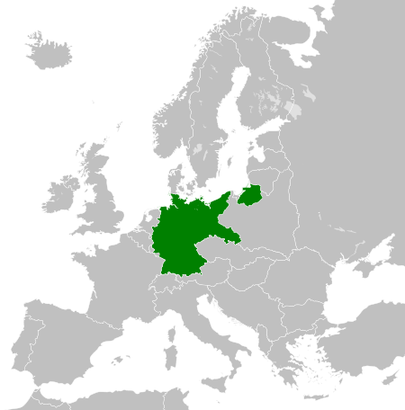
Fișier:Weimar Republic 1930.svg
 Mărimea acestei previzualizări PNG a acestui fișier SVG: . Alte rezoluții: | | | | .
Mărește rezoluția imaginii (Fișier SVG, cu dimensiunea nominală de 450 × 456 pixeli, mărime fișier: 483 KB)
| Acest fișier se află la Wikimedia Commons. Consultați pagina sa descriptivă acolo. |
Descriere fișier
Licențiere
- să partajați cu alții – aveți dreptul de a copia, distribui și transmite opera
- să adaptați – aveți dreptul de a adapta opera
- atribuind – Trebuie să atribuiți opera corespunzător, introducând o legătură către licență și indicând dacă ați făcut schimbări. Puteți face asta prin orice metodă rezonabilă, dar nu într-un fel care ar sugera faptul că persoana ce a licențiat conținutul v-ar susține sau ar aproba folosirea de către dumneavoastră a operei sale.
- partajând în condiții identice – Dacă modificați, transformați sau creați pe baza acestei opere, trebuie să distribuiți opera rezultată doar sub aceeași licență sau sub o licență similară acesteia.
Jurnalul original al încărcărilor
This image is a derivative work of the following images:
- File:Blank_map_of_Europe.svg licensed with Cc-by-sa-2.5
- 2011-09-19T22:57:58Z Alphathon 680x520 (603759 Bytes) Added North/Northern Cyprus
- 2011-08-23T10:26:48Z Heb 680x520 (604212 Bytes) Added ] (taken from ])
- 2011-04-12T00:40:40Z Alphathon 680x520 (602549 Bytes) Upgraded Sicily based on "File:Freeworldmaps-sicily.jpg". Upgraded Malta based on "File:Map of Malta 2.png". Simplified Croatian borders.
- 2011-04-10T21:43:04Z Alphathon 680x520 (607359 Bytes) Upgraded Croatia, Bosnia & Herzegovina, Slovenia and surrounding countries based on data from "File:Kroatien - Politische Gliederung (Karte).png"
- 2011-04-10T20:05:09Z Alphathon 680x520 (568373 Bytes) Improved Serbia, Montenegro and surrounding countries using data from "File:Serbia Map.png". Fixed Serbia-Montenegro border. Added Kosovo (using dashed border, since it is not a universally recognised nation, and left the lan
- 2011-04-10T15:55:02Z Alphathon 680x520 (524980 Bytes) Tweaked Ukraine and surrounding countries based on data from "File:Up-map.png"
- 2011-04-10T04:02:09Z Alphathon 680x520 (511168 Bytes) Improved Greece, Albania, F.Y.R. Macedonia and Bulgaria based on "File:Greece topo.jpg"
- 2011-04-10T02:48:52Z Alphathon 680x520 (505569 Bytes) Tweaked Germany and surrounding countries based on info from "File:Germany_general_map.png"
- 2011-04-10T01:54:05Z Alphathon 680x520 (493733 Bytes) Converted all lakes back to separate layer. Added Finish lakes and tweaked Finland shape based on "File:Finland 1996 CIA map.jpg". Added Swiss lakes based on "File:Suisse cantons.svg". Tweaked Scotland and added Lochs.
- 2011-04-10T00:07:54Z Alphathon 680x520 (450120 Bytes) Improved England outline and added Isle of Wight based on "File:England Regions - Blank.svg". Improved Denmark based on "File:2 digit postcode danmark.png". Improved Sweden based on "File:Map of Sweden, CIA, 1996.jpg"
- 2011-04-08T15:53:07Z Alphathon 680x520 (438878 Bytes) Upgraded/fixed various parts of the map. Details: *Some minor fixes to Ireland and added some of the larger lakes based on ] *Pretty major fixes to Scotland (mainly the west coast and i
- 2008-09-17T09:50:25Z F7 680x520 (531491 Bytes) '
- 2008-09-17T09:42:57Z F7 680x520 (2353 Bytes) '
- 2008-05-26T19:04:07Z Collard 680x520 (531491 Bytes) uploading on behalf of ], direct complaints to him plox: 'Moved countries out of the "outlines" group, removed "outlines" style class, remove separate style information for Russia'
- 2008-04-30T01:38:52Z TimothyBourke 680x520 (531767 Bytes) Changed the country code of Serbia to RS per and the file .
- 2008-02-08T22:44:37Z CarolSpears 680x520 (531767 Bytes) validated
- 2007-07-10T11:47:59Z MrWeeble 680x520 (533112 Bytes) Updated to include British Crown Dependencies as seperate entities and regroup them as "British Islands", with some simplifications to the XML and CSS
- 2007-05-14T17:17:34Z Zirland 680x520 (540659 Bytes) serbia and montenegro
- 2007-03-30T20:40:49Z W!B: 680x520 (538830 Bytes) minor corr: update nl:Ijsselmeer, del fi:lakes (all small), add ru:lake Oneka (all ref maps.google), glued northern irland back to ie ;)
- 2007-02-05T18:44:32Z Maix 680x520 (538295 Bytes) cropped
- 2007-02-04T15:07:29Z Maix 680x520 (538310 Bytes) {{Information |Description=A blank Map of Europe in SVG format. Every country has an id which is its ISO-3116-1-ALPHA2 code in lower case for easy coloring. |Source=Image based on ] by [[User:Ti
Uploaded with derivativeFX
Captions
românăAdd a one-line explanation of what this file representsenglezăRed:GermanyItems portrayed in this file
subiectul reprezentatstatutul drepturilor de autormaterial protejat de drepturi de autorlicențăCreative Commons Attribution-ShareAlike 3.0 Unported englezăînființare27 octombrie 2011tip MIMEimage/svg+xmlIstoricul fișierului
Apăsați pe Data și ora pentru a vedea versiunea trimisă atunci.
| Data și ora | Miniatură | Dimensiuni | Utilizator | Comentariu | |
|---|---|---|---|---|---|
| actuală | 24 aprilie 2018 06:47 |  | 450x456 (483 KB) | TRAJAN 117 | Update |
| 12 august 2013 11:00 |  | 450x456 (483 KB) | Alphathon | Fixed Yugoslav-Hungarian border (see main file) | |
| 25 iulie 2013 19:12 |  | 450x456 (469 KB) | Alphathon | Removed the Flevoland polders (Netherlands) which were not completed until 1942/1968 | |
| 27 octombrie 2011 06:00 |  | 450x456 (469 KB) | Alphathon | Minor tweak | |
| 27 octombrie 2011 05:49 |  | 450x456 (469 KB) | Alphathon | Tweaked Romanian borders | |
| 27 octombrie 2011 05:30 |  | 450x456 (465 KB) | Alphathon | A few minor fixes (Malta grouped with UK, North Cyprus removed, a few Greek islands moved to Italy per 1930 ownership). | |
| 27 octombrie 2011 05:10 |  | 450x456 (466 KB) | Alphathon | == {{int:filedesc}} == {{Information |Description={{en|A Map of the Weimar Republic within Europe circa 1930.}} |Source=*File:Blank_map_of_Europe.svg |Date=2011-10-27 02:10 (UTC) |Author=*File:Blank_map_of_Europe.svg: maix<sup>[[ |
Utilizarea fișierului
Următoarele pagini conțin această imagine:
Utilizarea globală a fișierului
Următoarele alte proiecte wiki folosesc acest fișier:
- Utilizare la af.wikipedia.org
- Utilizare la ar.wikipedia.org
- Utilizare la arz.wikipedia.org
- Utilizare la ast.wikipedia.org
- Utilizare la azb.wikipedia.org
- Utilizare la az.wikipedia.org
- Utilizare la ba.wikipedia.org
- Utilizare la bg.wikipedia.org
- Utilizare la bxr.wikipedia.org
- Utilizare la ca.wikipedia.org
- Utilizare la cs.wikipedia.org
- Utilizare la el.wikipedia.org
- Utilizare la en.wikipedia.org
- Utilizare la es.wikipedia.org
- Utilizare la fa.wikipedia.org
- Utilizare la fi.wikipedia.org
- Utilizare la fr.wikipedia.org
- Utilizare la ga.wikipedia.org
- Utilizare la gd.wikipedia.org
- Utilizare la gl.wikipedia.org
- Utilizare la gv.wikipedia.org
- Utilizare la he.wikipedia.org
- Utilizare la hi.wikipedia.org
- Utilizare la hu.wikipedia.org
- Utilizare la ia.wikipedia.org
- Utilizare la id.wikipedia.org
- Utilizare la incubator.wikimedia.org
- Utilizare la io.wikipedia.org
- Utilizare la it.wikipedia.org
- Utilizare la ja.wikipedia.org
- Utilizare la kk.wikipedia.org
- Utilizare la km.wikipedia.org
- Utilizare la ko.wikipedia.org
- Utilizare la ky.wikipedia.org
- Utilizare la lt.wikipedia.org
- Utilizare la mg.wikipedia.org
- Utilizare la mn.wikipedia.org
- Utilizare la mr.wikipedia.org
- Utilizare la ms.wikipedia.org
- Utilizare la pap.wikipedia.org
Vizualizați utilizările globale ale acestui fișier.
Informații
Acest fișier conține informații suplimentare, introduse probabil de aparatul fotografic digital sau scannerul care l-a generat. Dacă fișierul a fost modificat între timp, este posibil ca unele detalii să nu mai fie valabile.
| Titlul imaginii | A blank Map of Europe. Every country has an id which is its ISO-3166-1-ALPHA2 code in lower case. Members of the EU have a class="eu", countries in europe (which I found turkey to be but russia not) have a class="europe". Certain countries are further subdivided the United Kingdom has gb-gbn for Great Britain and gb-nir for Northern Ireland. Russia is divided into ru-kgd for the Kaliningrad Oblast and ru-main for the Main body of Russia. There is the additional grouping #xb for the "British Islands" (the UK with its Crown Dependencies - Jersey, Guernsey and the Isle of Man) Contributors. Original Image: (http://commons.wikimedia.org/wiki/Image:Europe_countries.svg) Júlio Reis (http://commons.wikimedia.org/wiki/User:Tintazul). Recolouring and tagging with country codes: Marian "maix" Sigler (http://commons.wikimedia.org/wiki/User:Maix) Improved geographical features: http://commons.wikimedia.org/wiki/User:W!B: Updated to reflect dissolution of Serbia & Montenegro: http://commons.wikimedia.org/wiki/User:Zirland Updated to include British Crown Dependencies as seperate entities and regroup them as "British Islands", with some simplifications to the XML and CSS: James Hardy (http://commons.wikimedia.org/wiki/User:MrWeeble) Released under CreativeCommons Attribution ShareAlike (http://creativecommons.org/licenses/by-sa/2.5/). |
|---|---|
| Lățime | 450 |
| Înălțime | 456 |


